Appalachian Trail - Piazza Rock

This popular, moderate hike features interesting rock formations to explore at the end of the journey and offers an introduction to the outdoors and the Appalachian Trail for families and children looking for an all-day outing.
Trail Activity
Snowshoeing Cross-country-skiing Hiking
Length
4.10 miles, Round Trip
Difficulty
Moderate, Advanced
Town
Sandy River Plt
Surface
Dirt/Forest Floor, Rock/Ledge
Pets
Permitted
Fees
No

Description

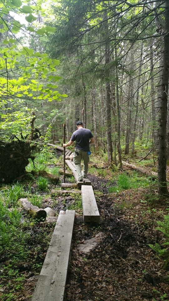
This is a pleasant and ideal family hike. It involves a relatively short distance combined with a few stream crossings and an enjoyable walk through the woods. The overall elevation gain is about 450' with most of the work done in the beginning third of the hike.

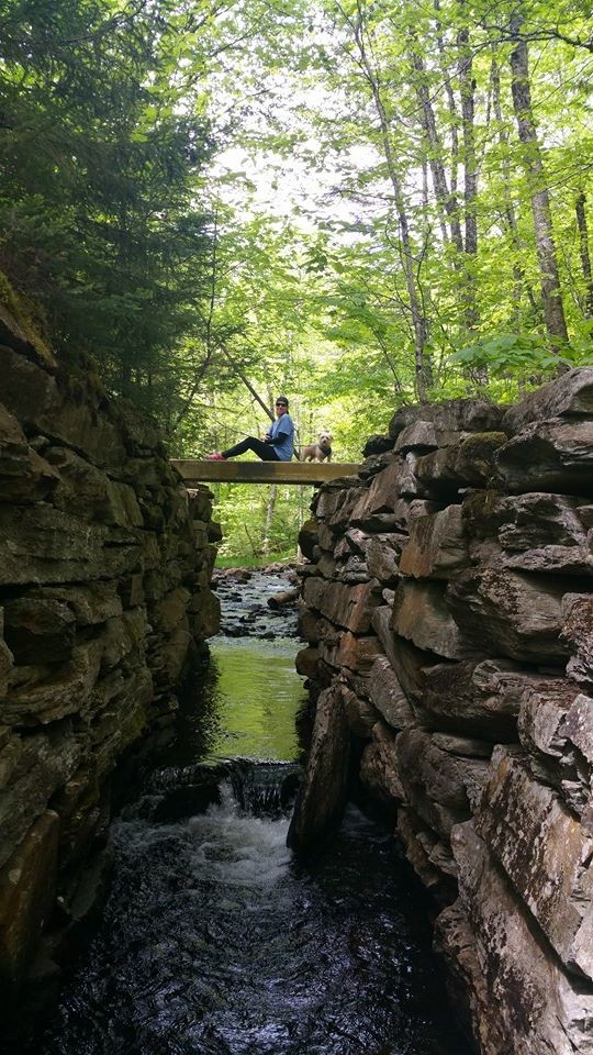
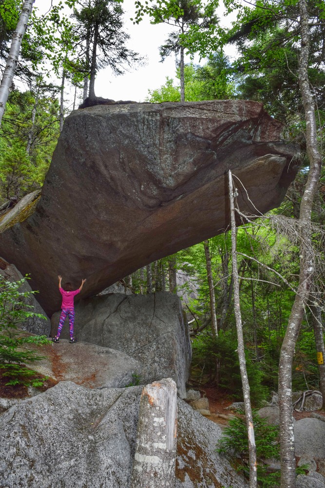
Beginning from the parking lot on ME Route 4, the trail crosses the road and enters the forest opposite the parking lot. Be careful crossing the busy highway. On your left, just prior to reaching the Piazza Rock Lean-To, is a  200 yard side trail which leads to the actual Piazza Rock. According to the geological notes about this area "The granite of Saddleback is jointed into huge building blocks. An unusually large one has slid out of its place in the mountain side and, instead of breaking and skating down the slope like the others, has balanced across another block to create one-half of a cantilever bridge, forming Piazza Rock."

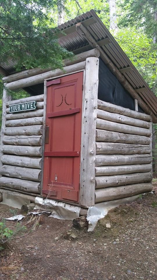
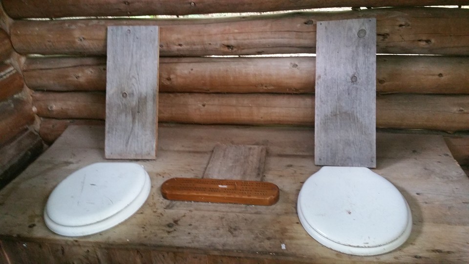
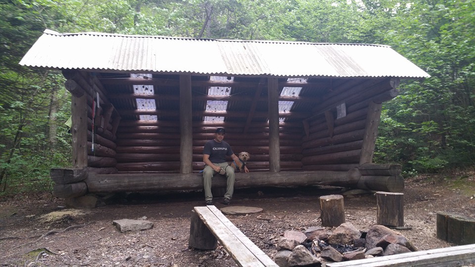
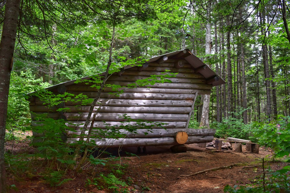
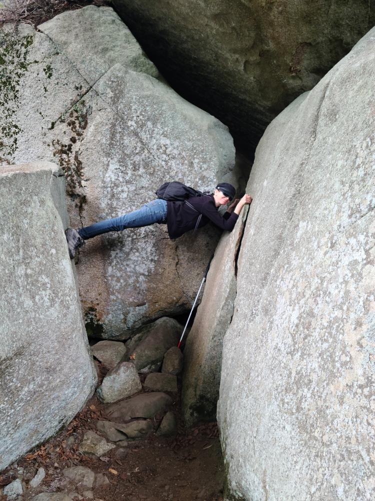
Hiking on brings you to the Piazza Rock Lean-To. It boasts a novel privy in that it is a "two-holer" with a cribbage board in between and has the name "Your Move." For the adventurous, you can hike 0.2 miles north of the shelter to the area known as "The Caves." These are boulder caves that were formed by rock fallen from the cliffs above. There are many narrow passages and care is advised when climbing through them. 

Other Information

Do not underestimate the difficulty of hiking the mountains of Western Maine. Be sure to carry equipment and supplies necessary for this undertaking. If you do not have the information or skills, be sure to research and educate yourself in order to have an enjoyable and safe hike. Be very aware of past, present, and predicted weather. Though the preserve is managed only for summer-time uses, winter uses like cross-country skiing, snowshoeing, and winter camping are allowed and popular.

Fires are only allowed in the provided fireplace ring at the Piazza Rock Lean-to. In the state of Maine, it is illegal to build a fire anywhere except within a certified fire ring. Camp stoves are permitted. Camping is not allowed above the tree line (a very delicate and vulnerable area to hike in), please stay on the trail.

The Maine Appalachian Trail Club (MATC) is an all volunteer organization that exists to maintain and protect the 267-mile section of the Appalachian Trail in Maine extending between Katahdin in Baxter State Park and Grafton Notch at ME Route 26. In addition, MATC maintains over 60 miles of side trails as well as a system of regularly spaced shelters and campsites in order that wild, backcountry hiking remains accessible in Maine. MATC publishes The Official Appalachian Trail Guide to Maine, which includes seven maps, please visit their website for information on how to purchase the guide or to learn more about becoming a member of MATC.

Trail Manager

Please contact the Bigelow District Overseer by email (bigelow@matc.org) to report any trail or shelter conditions that may require maintenance or special attention.

Visit Maine Appalachian Trail Club online for more information or contact:

Maine Appalachian Trail Club (MATC)

Maine Appalachian Trail Club (MATC)
PO Box 7564
Portland, ME 04112
info@matc.org
View website

Nearby Events

VIEW EVENTS CALENDAR

Trail Tips

Plan Ahead and Prepare
Find out about and follow any local regulations and respect landowners’ property.
Legend
Hide All

Trailhead Information

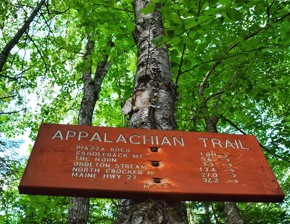
ME Route 4 crosses the Appalachian Trail in Sandy River Plantation, 30 miles north of Farmington or 9 miles south of Rangeley. Park in the lot situated west of the highway. Carefully cross ME Route 4 to head northbound on the A.T.

Click on a parking icon to get custom directions
Please Log In or Create Account to add comments.
bailey dog
June 18, 2021
Completed trip from Rt 4 to Piazza shelter, 2 holer, caves and the rock itself, 4 hr r/t, guess my thru hike is a long way off. Guess I can count this first time as my first 2 mile section hike, the roots are just wonderful, the down hills are as bad as the uphills. Enjoyed the experience however I could be confused for Bryson's partner- the approach trail in Ga would probably kill me.
bailey dog
June 02, 2021
Will be in the Rangeley area 6/13-6/18 and hope to hike to Piazza Rock from the near by high way parking. Wondering if any thru-hikers might be in need of a ride to-from town/trail. Please email me ahead of time at rnwellington@msn.com and maybe I can help you out.
hikealot
April 05, 2021
MILES LOGGED: 4.2 miles
ACTIVITY:
COMMENTS: Began at the Rt. 4 AT trailhead after crossing Rt. 4 from the AT parking area/sign. Trail crosses a small metal bridge over a little man-made granite block gorge, and ascends quickly with switchbacks and stream views. In a little less than a mile, you'll cross a dirt road (Beech). Continue to entry across, a bit to the left (not well marked) another 1.2, then left at AT sign/kiosk to ascend .1 to Piazza Rock, an amazing overhanging feature, with lots of rocks and caves to explore. Microspikes highly recommended this time of year. Shelter and more to explore a bit beyond the Piazza Rock turn off on the AT.
jralbert21
June 01, 2016
For you GPS users, the following are coordinates in decimal degrees to the various locations...
1) Appalachian Trail Parking spot: N 44.88686 x W -070.54057.
2) Dirt road that crosses trail: N 44.89234 x W -070.53520.
3) Caretaker's shed: N 44.90400 x W -070.53119.
4) Piazza Rock: N 44.90488 x W -070.53123.
5) Lean-to Hut: N 44.90413 x W -070.53002.
6) "Your Move" 2 Hole Outhouse: N 44.90425 x W -070.52982.
I listed where the road crosses in case you're not an avid hiker and you want to skip the majority of the climbing. You can park nearby to the crossing and the rest of the hike is fairly flat with very few log walkways over wet ground. If you do this though you'll miss a great brook near route 4 with a little bridge. Very scenic spot but if you just want to see the rock, you'll cut out the steep part and a long section of log walkways (mosquito heaven)!
These awesome businesses support our goal of connecting people to outdoor adventures in Maine!
Hang Tight!
Nearby services are loading
No Results
No Services Found
SHARE THIS TRAIL

Add Trail Log

Please wait…
Join In on the Fun!
Log in or create an account below to unlock all the great features of Maine trail finder: keep track of trails you want to do, preserve memories of trails you’ve done, earn badges, and more!
Your log in attempt was not successful. Please try again.
    Lost your password? Reset your password
    Don't yet have an account?
    There was an issue with your submission. Please try again.
      * Indicates required field
      Already have an account? Login here
      Enter your username, and we will send you a new, randomly generated password to your email account.
      There was an issue with your submission. Please try again.

        Success! A new password has been emailed to you.

        Log in now

        Please wait…