This is a 15 or 20 mile trip and will require a full day to run. It travels through some of the most remote country in southern Aroostook County. Much of the river is flat with a good current and occassional riffles. There is a series of pitches in the middle that should only be attemped by experienced paddlers.
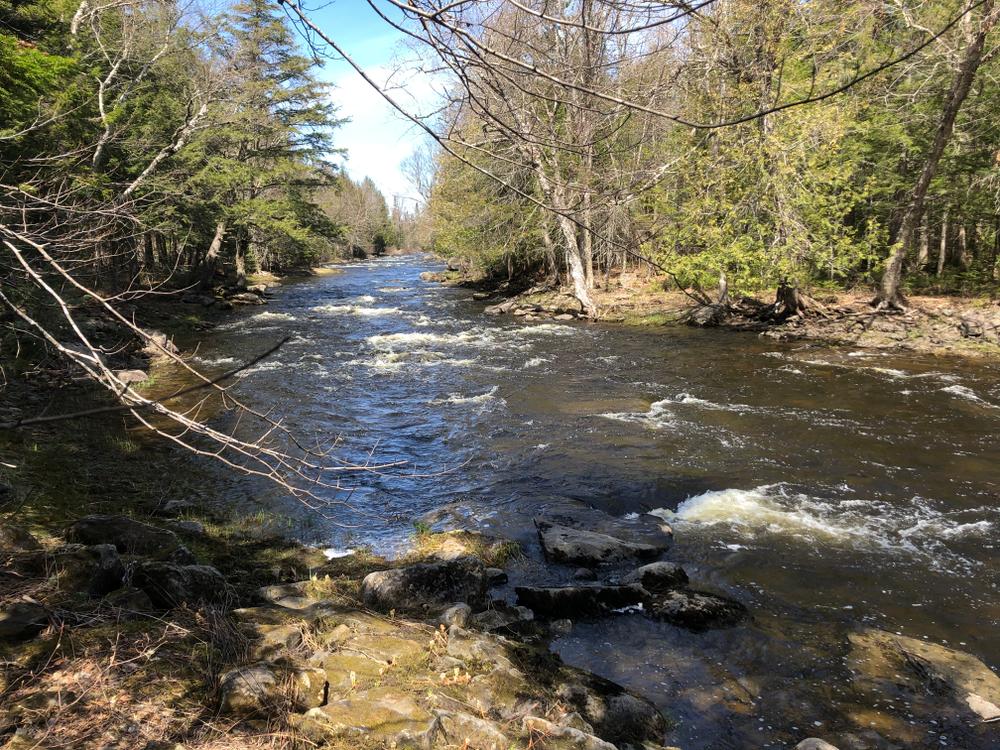
The put-in is at the Red Bridge off the South Oakfield Road in Oakfield. The first 5 miles of the river below Red Bridge is very pleasant, with fast water and some class I riffles. Wind towers are sometimes visible from the river through this section. A tributary from Pleasant Lake come in 2 miles down from Red Bridge.
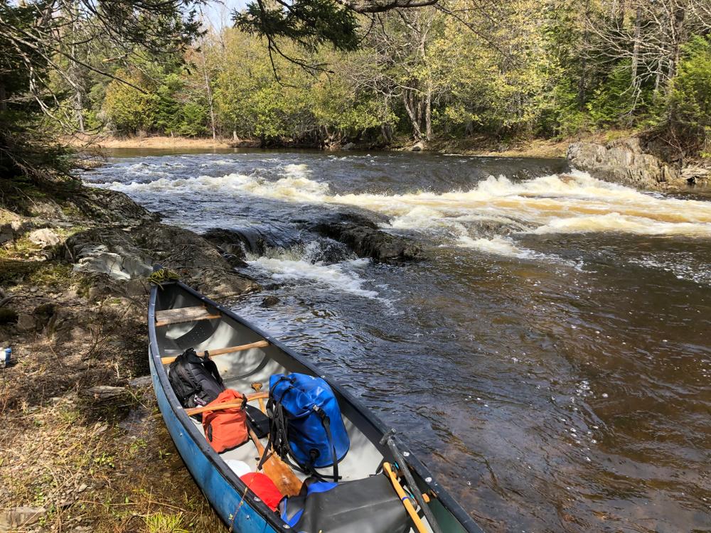
2.5 miles from the Pleasant Lake tributary and 4.5 below Red Bridge, begins a section of river referred to as Smooth Pitch, which is anything but. Smooth Pitch is actually a series of pitches, starting with a Class II rapid, with a left turn at the bottom into a pool. Below this is a three-quarter-mile section of a series of drops of Class II to IV whitewater that should not be run by anyone but the most competent paddlers, partucularly at times of high water. There is a portage trails to get around the many drops through Smooth Pitch on the right (west bank).
Near the end of this series of pitches is a narrow section at a snowmobile bridge, 5.2 miles from Red Bridge. Only very experienced paddlers should attempt it. The best portage trail is on the left bank.
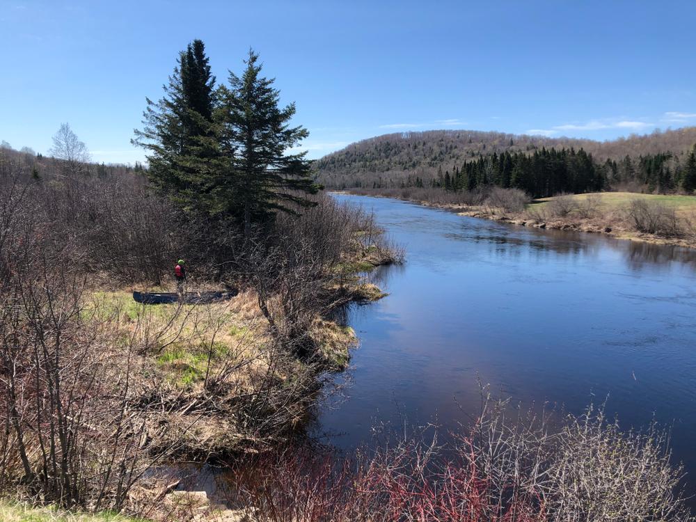
South of the snowmobile bridge there are two more pitches before the river returns to flatwater with a smooth, fast current to Haynesville. This section easy to negotiate with small rips interspersed among long deadwaters.
There is a take-out at the Bell Field Picnic Area Bridge in Forkstown, 15.5 miles from the Red Bridge put-in. There is also a take-out another 4.5 miles down river at the US-2A bridge in Haynesville.
From the Bell Field bridge to Haynesville, the river is all flatwater. It starts with a strong current, and becomes increasingly slow and gentle as a the current diminished. There is an exceptionally pretty section of the river on which overarching maple trees lean out over the river creating a green tunnel through which to paddle.
Just before the take-out by the Haynesville bridge, the river joins the West Branch of the Mattawumkeag, significantly widening the the river. Look for the take-out location on the right on the upstream side of the bridge.
This river can only be run in a canoe during spring highwater or after significant rain the rest of the season; with a kayak it is usually navigable during the course of the season except in abnormally low water conditions.
For additional information, visit the Aroostook County Tourism website, or contact:
![]()
Respect Private Land: Many landowners allow recreation on their land, but it’s up to you to confirm permission before entering.
RED BRIDGE PUT-IN
Take exit 286 off I-95 toward Oakfield and merge onto River Road/Smyrna Road. After 1.8 miles bear to the left to stay on River Road, and then continue another 2.6 miles to South Oakfield Road on the left. Cross over the Mattawamkeag to the put-in on the right, on the east bank and downstream side of the bridge. There is plenty of room to park.
HAYNESVILLE US-2A TAKE-OUT
From the south, take exit 227 off I-95, and go 2.2 miles on Access Road to ME-116. Take the left onto ME-116 N and go 6.1 to where ME-116 turns left, and head straight on North Chester Road. Go 0.6 miles and turn right on Chester Road. Go 0.4 miles over the Mattawamkeag and turn left on US-2. Go 18 miles on US-2 to where US-2 turns left, and continue straight on US-2A. Follow US-2A 19.5 miles to the US-2A bridge over the river. Just before the bridge on the left is the best location to take out, with plenty of space to park.
From the north, take exit 291 off I-95 and turn left on US-2 E. Go 3.6 miles and turn right on Campbell Road. Go 1.6 miles to Drews Lake Road on the left, then go 0.3 miles to New Limerick Road on the right. Take New Limerick Road 4.9 miles to South Oakfield Road. Turn left on South Oakfield Road, drive 1 mile, then turn right at the first cross street onto US-2A. Head south on US-2A for 15.2 miles to the Mattawamkeag in Haynesville. Just over the bridge on the right is the best location to take out, with plenty of space to park.
BELL FIELD ROAD TAKE-OUT
Bellfield Road is 3.9 miles north of the Haynesville take-out via US-2A.
From the south, take exit 227 off I-95, and go 2.2 miles on Access Road to ME-116. Take the left onto ME-116 N and go 6.1 to where ME-116 turns left, and head straight on North Chester Road. Go 0.6 miles and turn right on Chester Road. Go 0.4 miles over the Mattawamkeag and turn left on US-2. Go 18 miles on US-2 to where US-2 turns left, and continue straight on US-2A. Follow US-2A 23.4 miles to Bellfield Road on the left. Go 2.5 miles on Bellfield Road to the boat launch by the bridge over the river.
From the north, take exit 291 off I-95 and turn left on US-2 E. Go 3.6 miles and turn right on Campbell Road. Go 1.6 miles to Drews Lake Road on the left, then go 0.3 miles to New Limerick Road on the right. Take New Limerick Road 4.9 miles to South Oakfield Road. Turn left on South Oakfield Road, drive 1 mile, then turn right at the first cross street onto US-2A. Head south on US-2A for 11.3 miles to Bellfield Road on the right. Go 2.5 miles on Bellfield Road to the boat launch by the bridge over the river.
There is room to park by the Bellfield Road bridge.
Success! A new password has been emailed to you.