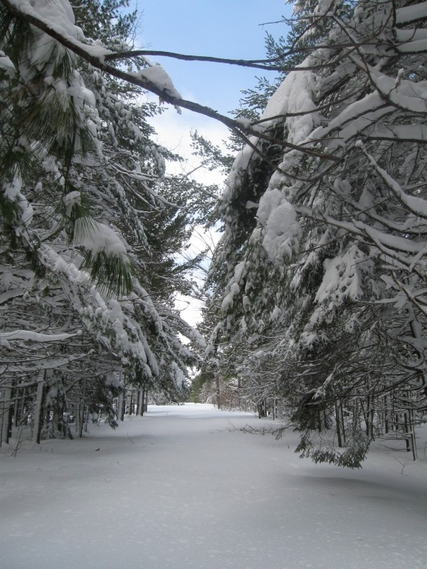
Most trails at the Edmunds Division are service roads with gentle grades. The refuge's landscape is varied, with rolling hills, large ledge outcrops, streams, lakes, bogs, and marshes. A northern hardwood forest of aspen, maple, birch, oak, spruce and fir dominates the upland. Scattered stands of majestic white pine are common.
The 3.5-mile Wilderness Trail begins at the Wilderness Area at either end of the gravel North and South Trail Roads. Only foot traffic is allowed on this trail. The Wilderness Trail runs through a varied landscape consisting of burned over areas that are re-generating, spruce and fir stands, an exemplary northern hardwood-spruce-fir forest, ledge outcrops, streams, bogs, and beaver flowages. The Wilderness Trail is comprised of the 0.9-mile North Trail and the 2-mile South Trail, connected by the 0.6-mile Camp Two Trail. To hike in a loop, follow the gravel service roads to return to your starting point.
Other trails:
Moosehorn is the easternmost National Wildlife Refuge in the Atlantic flyway, a migration route that follows the east coast of North America. Moosehorn's primary purpose is to protect wildlife, including migrating waterfowl, wading birds, shorebirds, upland game birds, songbirds, and birds of prey. The Edmunds Division covers 7,212 acres and contains a National Wilderness Area (2,712 acres) managed to preserve its wild character.
Camping, campfires, and motorized vehicles are not permitted on the refuge. Motorized vehicles and and mechanical transport (bicycles) are not permitted in the Wilderness Areas.
Cobscook Trails Project
The trails on Moosehorn National Wildlife Refuge are part of a larger network of hiking trails in known as Cobscook Trails. Cobscook Trails is a cooperative project of conservation landowners and community partners that seeks to expand opportunities for nature-based recreation and tourism in eastern Washington County. The group produces "Cobscook Trails: A Guide to Walking Opportunities around Cobscook Bay and Bold Coast Region," a 55 page booklet describing walks on 19 area properties. Find more information about Cobscook Trails, including how to purchase the guidebook, visit: The Cobscook Trails Project.
 Natural Heritage Hikes is a project of the Maine Natural Areas Program in partnership with Maine Trail Finder. View the "Moosehorn National Wildlife Refuge - Edmunds Division Wilderness Trail" guide online here.
Visit Moosehorn National Wildlife Refuge online for more information or contact:
Use Fire Rings: Only build fires in approved sites.
Moosehorn NWR (Edmunds Division) is located between Eastport and Calais along US Route 1 in the Downeast region (look for the large brown wildlife refuge signs). The refuge hiking trails are located across from Cobscook State Park.
In the winter, trailheads are directly off US Route 1. Park along the side of the road. In the summer months, the North and South Trail Roads lead to designated trailheads and parking. The roads form a one-way, clockwise loop: South Trail Road to Crane Mill Road to North Trail Road.
The Moosehorn NWR office (Baring Division) is located on Headquarters Road in Baring (~6.5 miles north of Calais). From US Route 1 take the Charlotte Road for three miles until you reach Headquarters Road on your right (look for the brown wildlife refuge signs). The refuge office is located half of a mile from the Charlotte Road turnoff. Visitors to the refuge are encouraged to stop at the refuge office to learn more about the refuge and pick up a trail map.
Success! A new password has been emailed to you.