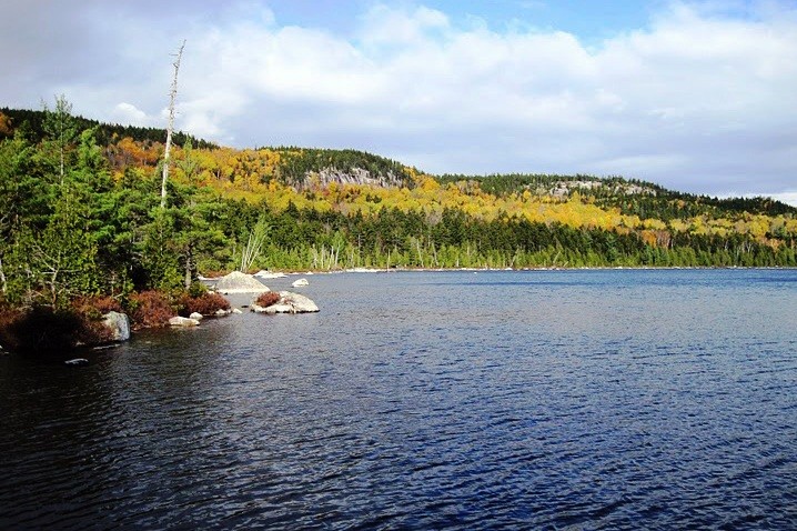
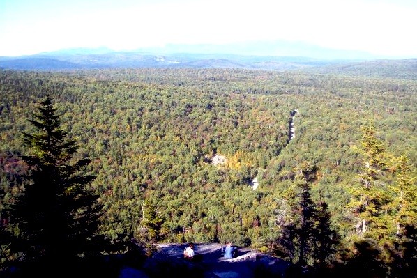
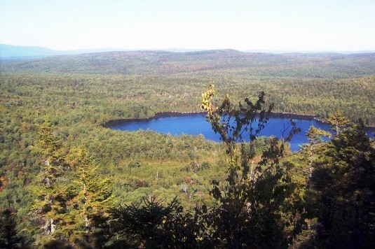
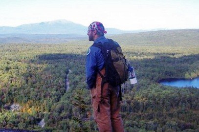
The Turtle Ridge Loop Trail provides a scenic hiking route passing by a collection of small and medium-sized ponds including Sing Sing, Hedgehog, Rabbit, Henderson, and Long Ponds. Anglers will find native brook trout in most of these ponds and ledges along the trail provide views of unbroken forests and mountains such as Maine's highest mountain, Katahdin.
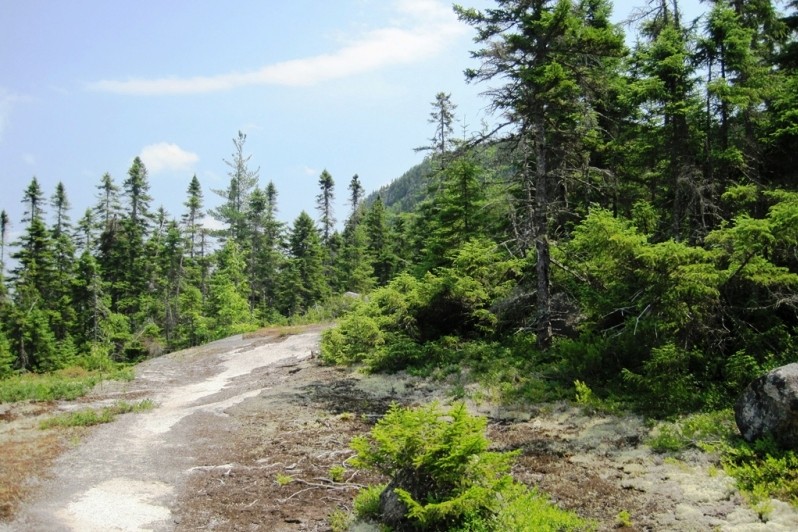
Starting at the west trailhead, head south down the road, cross a bridge, and follow the trail as it leaves the road on the left about 100 ft. from the bridge. The trail runs east through open hardwoods for just over one mile to a junction near the southwest corner of Sing Sing Pond (mislabeled on Google Maps as Harding Pond). The northern section of trail (left when travelling from the west) leads up a set of ledges on Turtle Ridge and reconnects 2.3 miles later near the northeast corner of Hedgehog Pond. Here, one can loop back 1.1 miles towards the first intersection via Sing Sing Pond's south shoreline or continue eastward.
To the east of the trail junction at Hedgehog Pond, there is a 3.5 mile loop meandering past Rabbit, Henderson, and Long Ponds. This loop also provides access to cliffs affording views to Katahdin and the lakes to the north and east. It should be noted that this eastern loop section has a short link to the east trailhead, the Jo-Mary Road, and the Tumbledown Dick Trail (3.2 miles - connects to the Appalachian Trail at Nahmakanta Stream). If starting from the eastern trail head, walk south from the parking area along the road to cross a bridge. The trail is on the right about 70 feet south of the bridge. Note: the separate but connected trail to Leavitt Pond is up the road (northeast) away from the bridge and on the right (look for pile of rocks and blue trail blazes).
View BPL's map of the Namakanta Public Reserve Lands.
Visitors arriving via ME Route 11 out of Brownville Junction or Millinocket and the private Jo-Mary Rd. must pay day-use fees at the Jo-Mary Gate between April and November. Season passes are available from North Maine Woods. Take care traveling along area logging roads, pulling over and stopping for trucks regardless of which direction they’re headed. Do not block roads. Gravel roads are hard on tires (and suspension systems): travel slowly and carry a spare tire.
Don't count on your cell phone in an emergency as coverage is spotty to non-existent. The Henderson automated checkpoint has a working phone for emergency use between mid-May and mid-October.
An extensive network of other hiking trails is available here, including a portion of the Appalachian Trail (AT) within the upper reaches of the 100-Mile Wilderness, considered by many to be the AT’s most remote section (though not a designated “wilderness area”). Day hikers and Backpackers alike should note the potential to string together days of hiking within Nahmakanta.
The Division of Parks and Public Lands maintains 5 authorized campsites with privies on Wadleigh Pond, 2 near Musquash Brook, and 2 on Pollywog Pond. On lands owned by the National Park Service bordering Nahmakanta Lake, there are six authorized sites where campfires are permitted. Fire permits are needed for the campsites at Pollywog Pond, Leavitt Pond and Tumbledown Dick Pond.
Of the 22 campsites, 9 are drive-to, 8 are boat-to, and 5 are walk-to. There are hand-carry boat launch facilities at Fourth Debsconeag Lake, Nahmakanta Lake, and Wadleigh Pond.

This trail passes through a property that was acquired in part with funds from the Land for Maine’s Future program. For more information about the LMF program and the places it has helped to protect, please visit the LMF webpage.
Visit Maine Bureau of Parks and Lands online for more information and a printable map or contact:
![]()
Protect Habitat: Stay out of nesting areas and keep pets leashed.
To Nahmakanta Public Lands: From Greenville access will be primarily over gravel roads and it will take approximately 1.5 hours. Drive northeast 15 miles to Kokadjo Village, leaving Greenville on Lily Bay Road. From here it is important to pay attention to millage and look for signs for Nahmakanta Lake Camps and Debsconeag Lakes, as there are many logging roads and doing these will help ensure you take the correct roads. From the outlet bridge over the Roach River at First Roach Pond (near the Kokadjo General Store) continue on and bear left at 0.3 miles. Follow Sias Hill Road (also known as Kokadjo-Ripogenus Dam Road). Go another 1.7 mile, and turn right onto Smithtown Road. Continuing on Smithtown Road, bear right at 3.2 miles continuing to follow the road, and then turn left after a total of 4.9 miles on the Smithtown Road. This left takes you onto the Farrar Mountain Road. In 4 miles, bear right and after 1 mile take a hard left. After another 1.8 miles, take a hard right. Bear left after 0.6 miles (use caution – approved ATV use begins on this road). Pass Penobscot Pond with camps on right, and reach boundary sign for preserve in another 1.4 miles.
From Brownville, leave ME Route 11 at the Jo-Mary Campground sign about half way between Brownville Junction and Millinocket (visitors must pay day-use fees at the Jo-Mary Gate between April and November; season passes are available from North Maine Woods). Proceed past the gate and take a right turn in 6 miles. The southern boundary of Nahmakanta Public Lands is in another 9 miles, just after the Henderson automated checkpoint.
Access to Trailheads: The Turtle Ridge Loop western trailhead is reached by traveling 1.2 miles south along the Long Pond Road, which spurs off the Nahmakanta Road approximately 1.5 miles after entering Public Lands from the west (look for blue yardarm sign). The Turtle Ridge Loop East Trail Head is located a little over 1.5 miles north of the Henderson Checkpoint, in the southeastern corner of the Public Lands.
Success! A new password has been emailed to you.