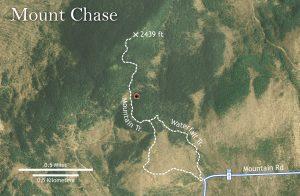
This an out and back hike, led by Milt Stein, of approximately 4 miles, with a vertical rise of 1,400 feet. Estimated time on trail including lunch and breaks is 4 hours.
The trailhead coincides with the IAT. This is a moderately difficult hike which starts on a tote road and gets steeper as we go. About a half mile from the summit, it becomes a hiking trail over granite ledge with roots, rocks, and gravel. We will pass a Warden’s cabin in route and there is a communications tower at the summit. On a clear day the views of Upper and Lower Shin Pond, Katahdin, and other nearby peaks are spectacular. At this time of year, we will be treated to the colors of the fall foliage as well.
We will meet at the Patten Recreation Area Parking Lot on ME-11 and the intersection of Me-159, and carpool from there to the trailhead on Mountain Road (8.5 miles).
Be prepared for any type of weather. Dress in layers, wear solid footwear appropriate for hiking in steep and wet terrain, and bring lunch, snacks, and water.
There is a limit of twelve participants; there will be a waiting list if we exceed that number.
Email trip leader Milt Stein, or register online.
For more information about the hike: See Mount Chase on the AllTrails app, the Map Adventures Katahdin Woods & Waters Trail Map, the Appalachian Mountain Club Maine Mountain Guide (11th edition), or view information online.

Success! A new password has been emailed to you.