Rumford Falls Trail

This trail system is currently PARTIALLY OPEN. See Trail Alerts tab for details.
The Rumford Falls Trail is an easy loop with a mix of sidewalk and gravel road that provides several spectacular views of the Falls, the Old Rumford Dam and the Androscoggin River.
Trail Activity
Hiking
Length
0.40 miles, One Way
Difficulty
Moderate
Town
Rumford
Surface
Gravel/Crushed Stone, Pavement
Pets
Permitted
Fees
No

Description

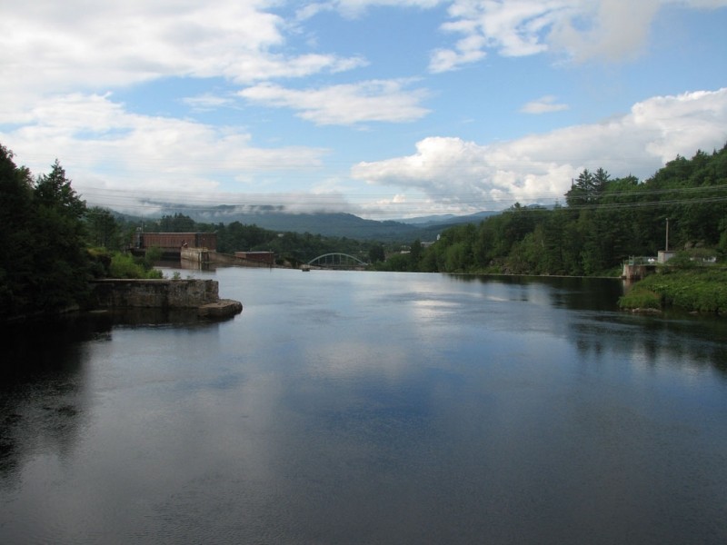
The Rumford Falls Trail follows sidewalks and a gravel road for a 1.6 mile loop. Heading in a counter-clockwise direction from the visitor center, the route goes moderately uphill on the sidewalk along US Route 2 for 0.5 miles. Turning left onto South Rumford Road, cross the Androscoggin River on a high bridge with great views of the dam and Rumford in the background. On the opposite side of the bridge, on the left, a gated gravel road heads northwards (downstream) parallel to the river. Along this section are lookouts that provide views of the dam and Rumford Falls. After 0.7 miles, the gravel road intersects Bridge Street (ME Route 108). Turn left (west) on the sidewalk and continue over two bridges and past a war memorial before returning to the visitor center parking lot.

Other Information

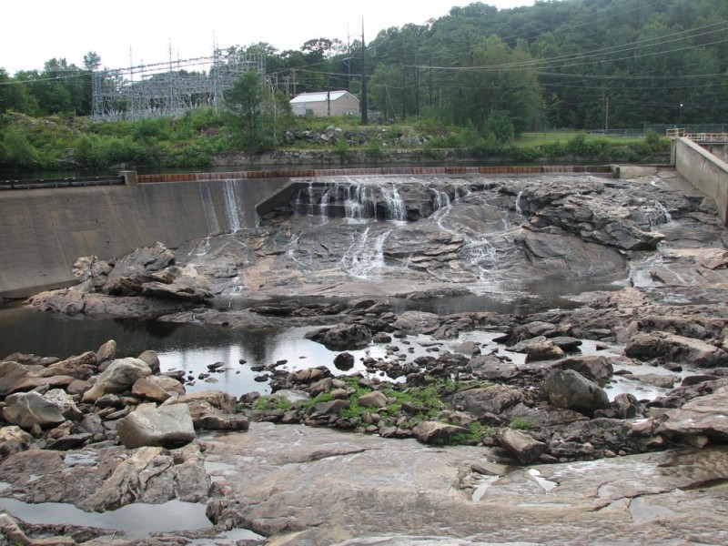
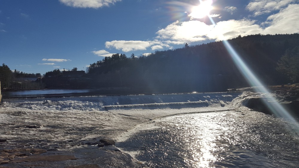
Originally referred to as Pennacook Falls or New Pennacook Falls, Rumford Falls is series of drops of the Androscoggin River. Although the river drops a total of 176 feet, dams have split the once continuous cascade into several distinct sections. The huge upper falls is still spectacular by any standard, especially in times of high water.

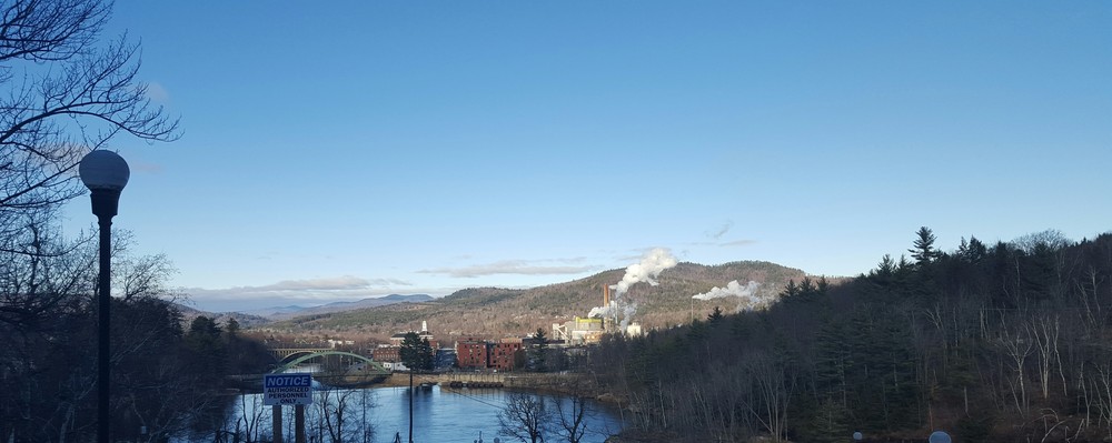
Bands of St. Francis Indians once hunted and fished here, where salmon spawn in the pool below Upper Falls. Sawmills and gristmills were built to harness water power from the falls, and in 1882, industrialist Hugh J. Chisholm recognized the falls' potential for the manufacture of paper. The first paper mill drew an infusion of people and money into the sleepy community of about 200 residents and the production of paper still dominates Rumford's riverfront and economy.

In "’The Only Man’: Skill and Bravado on the River–Drive" in Maine History Vol 41, No. 1, Edward "Sandy" Ives mentions David Severy, the only man to ride the Rumford Falls sluice in the early 20th century.

More historical information about Rumford Falls and the Town of Rumford can be found by visiting the Rumford Public Library online.

Trail Manager

Visit the Town of Rumford online for more information or contact:

Town of Rumford

Town of Rumford
145 Congress Street
Rumford, ME 04276
Phone: (207) 364-4576
mcollette@rumfordme.org
View website

Nearby Events

VIEW EVENTS CALENDAR

Trail Tips

Respect Wildlife
Keep your pets under control at all times, to protect both them and wild animals, fragile environments, and the enjoyment of other visitors.
Legend
Hide All

Trailhead Information

The Rumford Falls Trail can be accessed at several points along the loop. However, the visitor center and parking lot is the most convenient beginning and end point. The visitor center is on US Route 2 about 100 feet west of the intersection of US Route 2 and ME Route 108. The route can be done in either direction, starting on either side of the parking lot.

Click on a parking icon to get custom directions
Please Log In or Create Account to add comments.
mainer1983
May 28, 2022
Hey! Went to walk this today and is not a loop. The other two comments are correct. It’s private property and not passable. This trail should be removed from the site as an option. DO NOT bother trying it.
geekophelia
May 29, 2021
Traveling north to south on the wooded half of the loop (east of the river), there are at least 2 gates blocking the way. The first, where the trail divides, is a standard farm gate, plainly marked "private... No trespassing," but easy to walk around. The second is a tall cliff-to-ledge chain link fence, where the same sign seems much more threatening. It might be POSSIBLE to bypass it one end by holding onto barbed wire and hanging over the cliff, but it'd also be really stupid and apparently illegal. We turned around and tried the other farm gate at the fork, just for chuckles, and sure enough, that isn't the route, either. So, not a loop trail, and not much of a hike if you stop at that first gate.
mainetrailfinder
December 16, 2015
radtastic, this trail was reviewed and approved with the town before posting. Our understanding is that the route is still open for public use.
radtastic
December 16, 2015
I tried to walk this trail today, but the part off of 108 has two gates. One is marked as Private Property, and one is for the dam. I assume that the trail goes over private property. Is it known if it's alright with the landowner to pass their gate. I believe that this same section is part of a snowmobile trail
These awesome businesses support our goal of connecting people to outdoor adventures in Maine!
Hang Tight!
Nearby services are loading
No Results
No Services Found

Trail Alerts

Trails
Public Access on Hold

Public access between the gates is currently on hold. Check back for updates. 

SHARE THIS TRAIL

Add Trail Log

Please wait…
Join In on the Fun!
Log in or create an account below to unlock all the great features of Maine trail finder: keep track of trails you want to do, preserve memories of trails you’ve done, earn badges, and more!
Your log in attempt was not successful. Please try again.
    Lost your password? Reset your password
    Don't yet have an account?
    There was an issue with your submission. Please try again.
      * Indicates required field
      Already have an account? Login here
      Enter your username, and we will send you a new, randomly generated password to your email account.
      There was an issue with your submission. Please try again.

        Success! A new password has been emailed to you.

        Log in now

        Please wait…