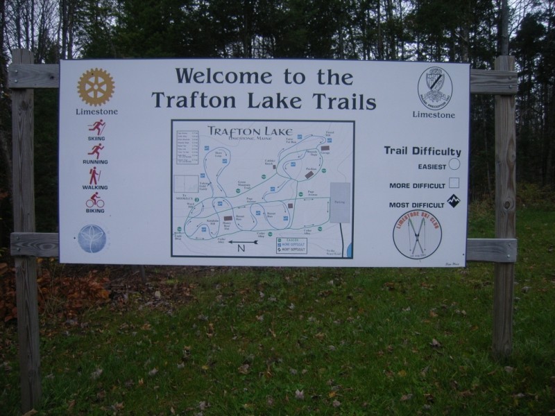
Trafton Lake Trails offer easy looping trails that meander through hardwood forests and the edge of potato fields. The trails can be split into two categories described below: easier green trails and more moderate blue trails.
Trafton Green (Cedar Run, Page Alley, Green Mountain): These straighter trails are ideal for easy classic skiing in the winter and are also the most heavily used in the summer with dirt or gravel surfaces.
Trafton Blue (Russet Run and Shaw Loop): These are more windy trails and, while generally easy, include some short steep climbs and descents. In the summer, the trails are mostly grass surfaced and, in the winter, they are occasionally groomed for skiing. These frequently cross the Green Trails.
School Connector Trail (not shown): This is an easy trail that passes along the edge of fields from the north end of the Trafton Trails and finishes on the athletic fields behind the school. There is also a short detour through a nice wooded section.
For more information please contact:
Limestone Ski ClubFrom ME Route 89 between Caribou and Limestone, turn south about a mile outside downtown Limestone, onto Ward Road. In a mile the road intersects Bog Road; continue straight on Ward Road another 0.8 miles, and turn east (left) onto Lake Road and follow it to the end at Trafton Lake (follow signs). There is a parking lot at the end of the road. The trailhead for the network starts at the north end of the parking lot near the campground and is indicated by an information board on a building on the left near the woods.
From US Route 1A, turn west onto Bog Road just south of downtown Limestone. In just over a mile, turn south (left) onto Ward Road and follow the directions above to the trailhead. A connector trail (not shown) can also be used to access the trails form the High School in downtown Limestone.
Success! A new password has been emailed to you.